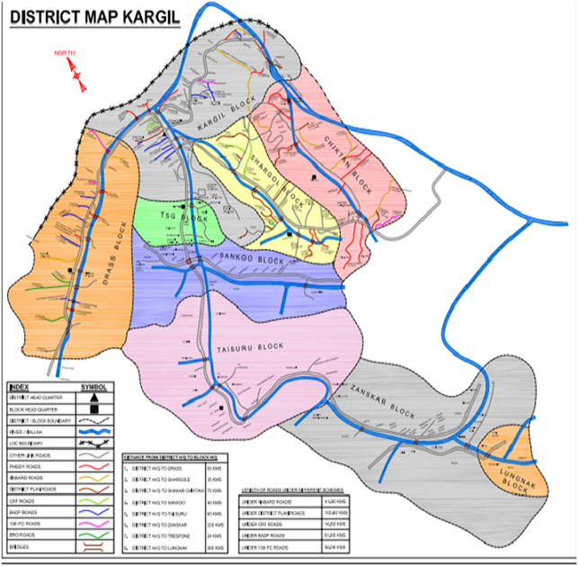
The word Kargil is derived from khar meaning ‘castle’ and rkil meaning ‘centre’. It is one of the remotest districts in the country covering an area of 14086 Square kilometres. The population of the district is 1.40 lakh according to 2011 Census. It is connected by the Zojila Pass with the rest of the country and during winters, the whole of District Kargil remains cut off from the rest of the world.
The District has been divided into four Sub-Divisions i.e.
(i) Drass
(ii) Zanskar
(iii) Sankoo and
(iv) Shakar - Chiktan.
Ladakh was an independent kingdom till 1834. The Dogra General Zorawar Singh invaded Ladakh and annexed Ladakh as a part of the Dogra Dynasty in 1834. Under the Dogra rule, the region was divided into three Tehsils— Leh, Kargil and Skardo. Some parts of the Kargil Tehsil and almost the whole of Skardo are currently under the illegal occupation of Pakistan. In 1961, Zangskar was also made a Tehsil.
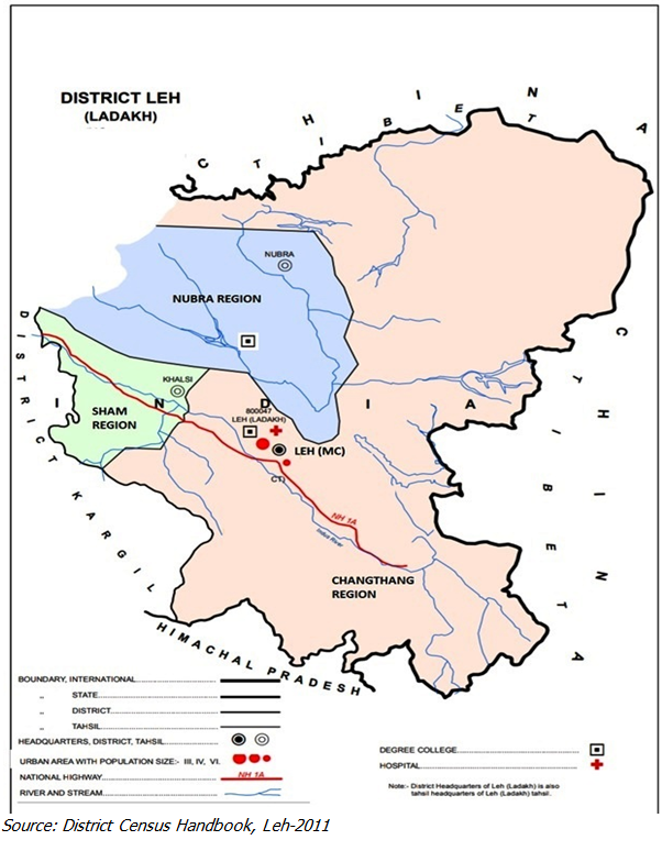
In 1979, in order to decentralise the administrative and developmental activities through Single Line Administration, Ladakh District was bifurcated into two separate districts— Leh and Kargil. Leh Tehsil was, subsequently, divided into three sub-divisions— Nubra (HQ Diskit), Changthang (HQ Nyoma) and Khaltsi under the overall control of the Deputy-cum-Development Commissioner, Leh.
| Administrative Profile | |
|---|---|
| Units | Number |
| Sub-divisions | 6 |
| Tehsils | 8 |
| Blocks | 16 |
| Panchayats | 95 |
| Revenue Villages | 119 |
| Municipal committee | 1 |
Politically, the district is governed by the Ladakh Autonomous Hill development Council (LAHDC), Leh with 30 Councilors (26 elected and 04 nominated) headed by the Chairman /Chief Executive Councilor (rank of State Cabinet Minister) who is assisted by four Executive Councilors since 1995.
In 2014, three new Sub-Divisions (Durbuk, Kharu and Liker), five new Tehsils (Nyoma, Saspol, Kharu, Durbuk and Diskit) and nine new blocks (increasing the number of blocks to 16) have been created.
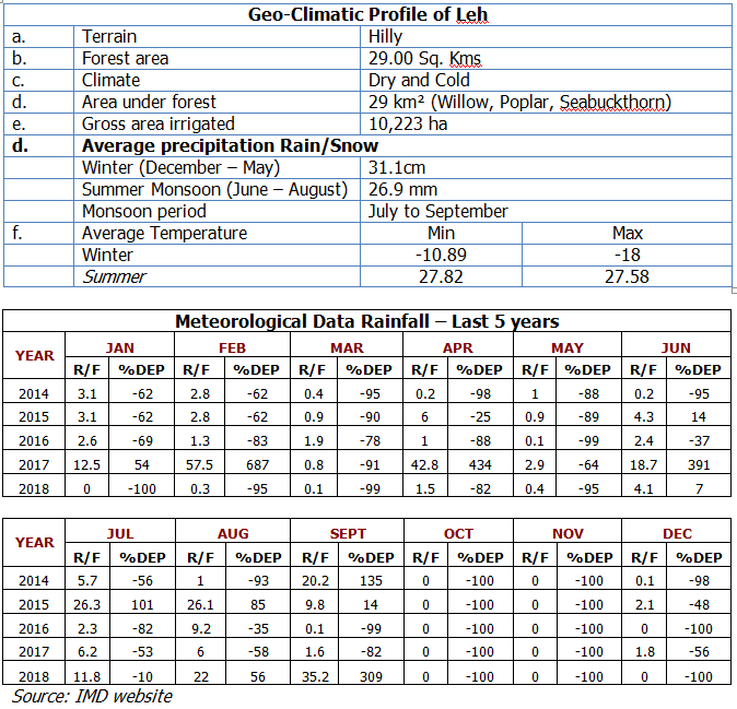
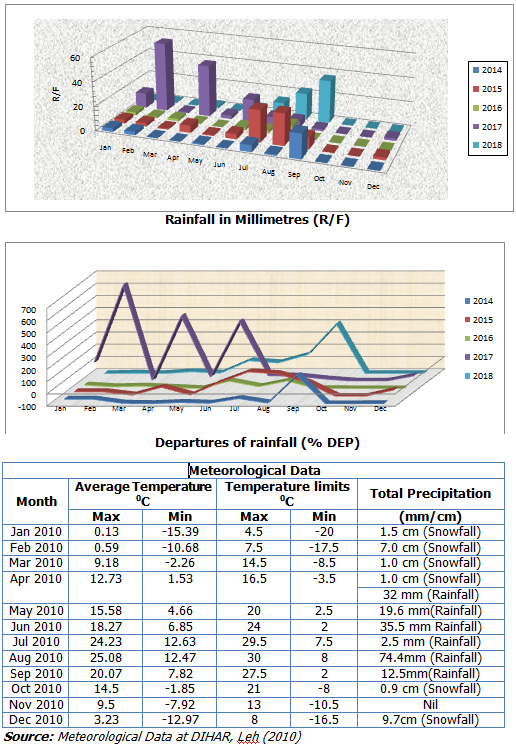
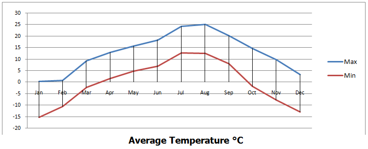
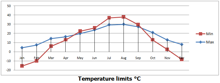
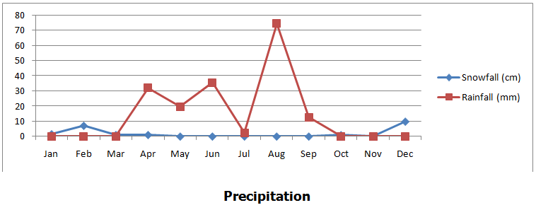
The climate of Ladakhcan be divided into two main seasons: winter and summer with short spring and autumn season (Winter: Nov-April;Spring: May-June: Summer: June-Aug; Autumn: Sep-October). Average annual rainfall is 40-70mm. Max. Temperature goes up-to about 350Cand minimum goes down to -400C. On clear sunny days, when the average temperature increases, the sun can be scorching hot with deep intensity and its ultra violet rays cause deep sun burn. The growing season is restricted due to longer winter; the agriculture season is short and spread over from April to September depending upon the climate. The climate varies in different valleys of the district which influences the period of agricultural activities, type of farming, nature and variety of crop method of cultivation. Wind speed is very high particularly during the period of April-May. It may touch 50-60 km per hour. Wind speed increases in the afternoon. However, Humidity remains less than 40% for most part of the year. High wind speed combined with low humidity leads to increased water loss in the form of evaporation and transpiration which necessitates continues irrigation to plantations for their survival.
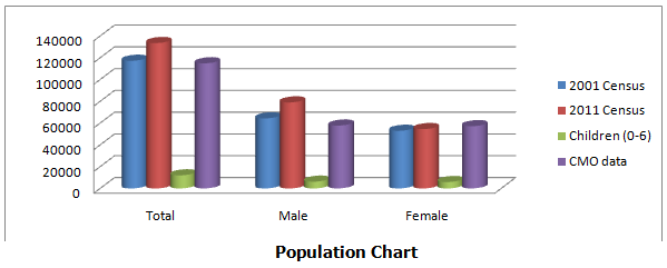
The 2011 census recorded that the total population of Leh district was higher than that given in the Health Department, Leh’s survey done in 2018. The significant increase in the number of population and the skewed gender ratio in the 2011 census is a result of inclusion of Military, Paramilitary Forces Migrants etc. from other parts of the country residing in Leh as part of Leh’s population.
Out of 133,487 total population of the District, Leh town has a share of 45,671 souls. As per 2011 census, there are 690 females for every 1000 males in the district, as against 814 in rural sector and 494 in urban sector.However, this the skewed gender ratio does not depict the real picture. It’s, in fact, a result of inclusion of Military, Paramilitary Forces Migrants etc. from other parts of the country residing in Leh as part of Leh’s population.
| Demographic Profile of the District | |||
|---|---|---|---|
| Population | As per 2001 Census | As per 2011 Census | Health Deptt. Leh’s Record(2018) |
| Total | 117232 | 133487 | 114884 |
| Male | 64306 | 78971 | 57725 |
| Female | 52926 | 54516 | 57159 |
| Children (Age 0-6) | Male: 6174 Female: 5842 | ||
| No. of households | 21909 | 19751 |
| Demographic Profile of Leh Town | |||
|---|---|---|---|
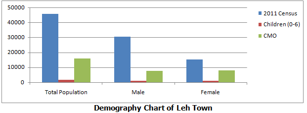
| Population | As per 2001 Census | As per 2011 Census | Health Deptt. Leh’s Record(2018) |
| Total | 28639 | 45671 | 15811 |
| Male | 17772 | 30560 | 7763 |
| Female | 10867 | 15111 | 8048 |
| Children (Age 0-6) | Male: 854 Female: 843 | ||
| No. of households | 4377 | 3246 |
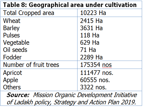
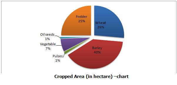
Agriculture in Leh is subsistence. Nearly 70% of the population is directly or indirectly dependent on this sector. Despite the vast geographical area, 62% of the households have less than 1 hectare of cultivable land. Single-cropping is pre-dominant in most of the regions and double-cropping limited areas falling below an altitude of approximately 3,000 meter. Glaciers are the main source of water for irrigation and the rivers that flow in the region remain underutilised for agricultural purpose. The total cropped area in Leh district is 10,223 hectare and thus only 0.2% of the total geographical area is under cultivation.
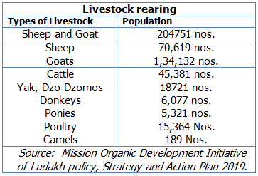
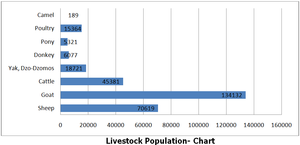
Farmers mostly practise mixed farming where livestock rearing is an integral part of the system for food and manure. There has been considerable variation in number of livestock across blocks with Nyoma, Rupsho-Puga and Durbuk showing the highest number and Leh, Thiksay and Rong-chumathang showing the lowest.
Cloudburst is an extreme weather event in which very heavy rainfall occurs over a highly localised area in a very short time span. Cloudbursts in India occur during monsoon season over mountain regions in the Himalayas, north-eastern states and the Western Ghats. The associated convective clouds can extend up to 15 km above the ground. The phenomenon of 2010 flash-flood was primarily because of cloud burst or intense rain. However, Leh has flash-flood record of other types as well.
Glacier Lake Outburst Flood (GLOF) and river blockade caused by rock fall/landslide blockade are other two potential disasters especially in areas like Ladakh. GLOF of late has become a very common phenomenon in Ladakh.
A well known scientist in the field says that “The past climatic signatures are well imprinted in the geomorphology of the region, when we consider formulating strategies to adapt to climate change for region like Ladakh. It is pertinent that past signatures of climatic changes and events are taken into consideration for formulation of adaptations strategies in future. One of the key tools for such planning is the preparation of large scale geomorphological maps of the area in question. This is necessary in locating the best location for development and settlement of people, in areas which are free from past catastrophic events. Many of the past glacial recessional features can be utilised for conservation and management of melt waters of glaciers. This makes it a must before going ahead with formulation of any practical development of region” .