
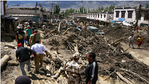
Cloud Burst and Flash Flood has become a very common phenomena in the district of late. These generally occur between June and September. Flash Flood of 2010 was the most devastating till date in terms of loss of life and property. Analysis by the India Metrological Department http://www.imd.gov.in/ of satellite images of 4th– 6th August 2010 indicated that an intense convective system developed in the easterly current which is associated with the monsoon conditions over the region. The convective cloud band extended from the southeast to the northwest over Nepal and India during the afternoon of 5th August. It gradually intensified and moved west-northwest towards the Ladakh region. An intense convective cloud cluster developed to the east of Leh by 21:30 IST on 5thAugust. Geologically, the region around Leh is made up of granites and loose sediments. The mountain slopes around Leh are covered in loose, unconsolidated deposits. Large fans of loose sediment, which are the product of several million years of erosion, can be observed in many locations along the banks of the Indus River. These sediments become dislodged and move rapidly when the surface layer becomes heavily saturated. The very heavy rainfall over Nimoo-Basgo and Leh on 4th – 6th August saturated the loose sediment, setting off mudslides and sand flows which travelled down-slope towards the Indus River. The destruction at locations throughout Leh district was due to the rapid movement of huge volumes of water charged with mud, boulders, trees, building debris and other objects swept up in the flow. At Choglamsar (among the worst affected areas), the debris flow travelled approximately 10km from the epicentre of the cloudburst (near Saboo), spreading up to 2km. In Leh, the debris flow travelled about 3km, from an elevation of 3800m to 3410m, confined to the catchments of Shakshaling stream. The flow destroyed settlements, the Bus Stand and the BSNL mobile communications hub and damaged the Sonam Norboo Memorial Hospital and the radio station. The worst affected areas including Leh town were Choglamsar, Tashi Gyatsal area of Choglamsar, Saboo, Taru, Nimoo, Basgoo, Stakna, Shey, Arzoo Thiksay, Kungam, Anlay, Nidder, Achinathang Lungba, Skurbuchan, Rezong, Ulley, Tia, Temisgam,Tyakshi in Turtuk area.About 233 human lives were lost, 424 peoples injured and about 79 peoples are still missing. Similar incidents of cloud burst resulting in low intensity flooding and mud slides were also reported during 2006, 2012, 2016 and recently in 2018. It is the consequences of such heavy rain, especially in the hilly terrain, causes death and destruction. There is a scarcity of past data on cloudburst; and, there is also a problem of accuracy as well. Under global climate change scenarios, the frequency of high intensity rainfall events is expected to increase and consequently frequency of cloudburst events may also increase in the near future.